
PDF preview shows how traffic signs will sit on paper while you are still drawing. It is not a download. It is an on-map rehearsal for an XL export page: signs shrink or grow to the paper-relative size of the selected XL rectangle and Paper size.
Use this when a Demo traffic plan covers a long Utrecht corridor and Detail pages cannot frame the whole works without shrinking signs below a readable size. Skip it for a single junction that already fits a Detail map. Skip it if you only need a share link.
The control lives on the right of the map, with Enable sign stacking and Show labels. It is a Pro tool. Paying for unlimited signs on one plan (Paid) does not turn it on. If you cannot see it, read Feature not available for my account.
The customer-facing name is PDF preview. Older internal notes said “Big Picture”. The app does not use that name on the button, the tooltip, or the toasts.
Who can use it
PDF preview only appears when your account can manage XL maps (the same Pro gate as Displace sign stack and XL under Draw new map).
Without that permission:
- The PDF preview chip is missing in edit mode.
- In Export maps, XL stays disabled with a Pro badge and XL maps require a PRO account.
Read-only viewers never see PDF preview. Sketch tools and the scale slider are also hidden for them. Organization members who are not the assigned editor are read-only, so they cannot turn preview on either.
The tooltip on the chip is Preview this plan at the selected export paper scale. Hover Show PDF preview when the state is Off, and Hide PDF preview when the state is On.
On and Off
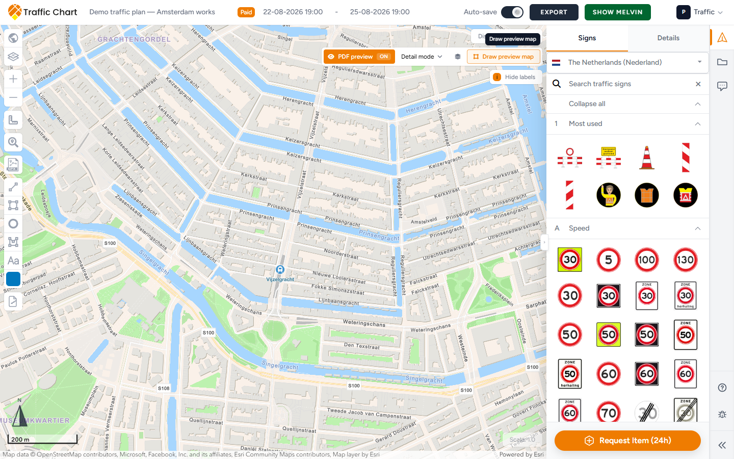
The chip reads PDF preview plus a state badge. The labels on this control are PDF preview On / Off, Select XL map, Draw XL map, Lock preview map, and Scale cannot be changed while PDF preview is on.
| State | Badge | Tooltip |
|---|---|---|
| Preview off | Off | Show PDF preview |
| Preview on | On | Hide PDF preview |
- Click PDF preview to turn it On. The chip turns orange.
- Click it again to turn it Off. Signs return to normal editor size.
Turning On does not download a PDF. It also does not create an export file. You still use Export → Export files when someone needs a document. Export and print traffic plans.
While On, extra controls appear next to the chip: a map selector, a manage-export shortcut (when the selector is empty), and a draw button.
Detail mode versus XL map 1
With preview On, a dropdown appears. The empty option is Detail mode. Each existing XL rectangle is listed as XL map 1, XL map 2, and so on.
| Choice | Meaning |
|---|---|
| Detail mode | No XL rectangle is driving the preview. Signs are not sized to a paper page. Use this while you only want preview off the XL context, or before you have drawn an XL map |
| XL map 1 | That XL rectangle and its Paper size become the sizing context. Signs on the whole map preview at that paper-relative size, not only the signs inside the rectangle |
The dropdown tooltip is Select XL map.
Only one XL map is active for preview at a time. You can store several XL rectangles for export, but the editor preview uses the one you pick here.
Detail mode in this dropdown is not the same as a Detail export map. Detail export maps still exist in Export maps. They keep a maximum real-world size so signs stay readable. XL maps do not have that maximum; they cover a large area and scale signs to the paper.
If the selector is sitting on Detail mode (empty), a layers button appears next to it. Tooltip: Manage export maps. It opens Export maps so you can inspect Map 1, change Paper size, or draw another rectangle.
A plan can mix both types. Example: XL map 1 as an overview of Amsterdam works on A3, plus three Detail maps for junctions. Preview only cares about the XL map you select.
Draw an XL map for preview
Preview needs an XL rectangle and a paper size. Without both, the app cannot compute a paper-relative sign size.
If you have no XL map yet, the draw button is labelled Draw preview map. After you have at least one XL map, the same control shrinks to a plus icon. Tooltip: Draw new XL map.
Steps
- Turn PDF preview On.
- Click Draw preview map (or the plus icon).
- A popover opens with Paper size. Series are grouped (A-series, and Other for anything ungrouped). A4 is the default when it exists.
- Pick the paper you will actually print, for example A3. You can still use Change orientation on the rectangle later.
- Click Draw XL map. The popover closes.
- A toast appears: Draw an XL map on the map. Drag a rectangle over the works.
- After the rectangle exists, a second toast: XL map created. Unlock the preview map to move or resize it.
- The dropdown switches to XL map 1 (or the next number).
If you click the draw control again while a draw is already in progress, the same prompt repeats: Draw an XL map on the map.
Cancel the draw (Escape, or click away as the map allows) and no rectangle is stored. PDF preview can stay On; pick Detail mode until you draw again.
You can also create XL rectangles from Export → Export maps → Draw new map → XL. Those maps appear in the PDF preview dropdown as XL map 1, XL map 2, and so on. Preview still needs you to select one of them.
Without Pro, XL in that sidebar stays disabled: XL maps require a PRO account.
Paper size on the preview rectangle
Once an XL map is selected, a small toolbar sits on the top edge of the rectangle (the same chrome as in export mode, plus a lock).
| Control | Does |
|---|---|
| Lock | Lock preview map / Unlock preview map (preview only; see below) |
| Paper size | A4, A3, and the other sizes in the list that this rectangle allows |
| Export type | Detail or XL. Preview sizing only uses XL |
| Change orientation | Portrait or landscape |
| Remove export map | Deletes that rectangle |
Match what the municipality or printer asked for. An XL map on A4 is valid. Content scales to that page. It is not infinite paper.
Changing Paper size or orientation immediately changes how large signs look in preview. Zooming the map does not. If a stack occupies about a tenth of the page, it keeps that relationship while you pan.
Switching the type to Detail takes the rectangle out of the PDF preview dropdown. Use XL for preview.
Remove export map deletes the rectangle. If it was the active preview map, the dropdown falls back to Detail mode.
If a Detail rectangle hits its limit: This detail map has reached its maximum size. Switch it to XL map if you want to export a larger map. That message is about Detail maps in export, not about preview itself. Convert the rectangle to XL if Pro allows, or draw a new XL map from PDF preview.
Lock preview map and Unlock preview map
New XL maps start locked for preview. That is why the create toast says Unlock the preview map to move or resize it.
| State | Button | Use |
|---|---|---|
| Locked | Unlock preview map | Click signs, stacks, and sketches through the rectangle |
| Unlocked | Lock preview map | Drag or resize the XL rectangle itself |
While the rectangle is unlocked, clicks on objects inside it can be captured as rectangle edits. If you try to select a sign through an unlocked preview map, a toast says Lock the preview map to select this object.
Typical rhythm for a Demo traffic plan:
- Unlock preview map, frame the Utrecht works, set Paper size.
- Lock preview map.
- Place, Displace sign stack, and tidy labels at paper scale.
- Unlock preview map only when the frame is wrong.
Displace sign stack is the Pro tool that draws a stack away from its real coordinate with a leader line. It is especially useful while PDF preview is On, because crowded junctions overlap more once signs are paper-sized. Advanced sign placement.
Show labels / Hide labels still work in preview. Crew Labels that looked fine at screen size can collide on A4. Fix them while preview is On.
Scale is disabled while preview is on
Scale: (bottom right of the map, default 1.0) cannot move while PDF preview is On. The control looks faded. Hover or focus it: Scale cannot be changed while PDF preview is on.
That is deliberate. Preview sizing comes from the XL rectangle and Paper size, not from the editor Scale: slider. Turn preview Off if you need to change Scale:.
If you do change Scale: later (preview off) and the plan already has Detail export maps, confirm Confirm scale change.
The dialog body: To ensure optimal results with the new scale (0.5), your detail export maps will be reset and need to be redefined. The scale function gives you more control over the size of objects like lines and traffic signs. (the number is the scale you picked, for example 0.5).
Notes in that dialog:
- Scale 1.0 is the default. If you lower the scale (e.g., to 0.5), all objects will shrink, and detail export maps must be redrawn. This helps keep traffic signs readable when exported or printed.
- PDF preview and XL maps will be kept because their scale is based on the selected export map.
Confirm only if you accept redrawing Detail maps. Drawing and measuring.
Do not fight Scale: while preview is on. The disabled tooltip is the whole answer.
How preview relates to a real PDF
PDF preview is a drawing aid. It is not a substitute for opening the downloaded file.
After you like the paper-scale layout:
- Turn PDF preview Off if the extra chrome is in the way (optional; export mode has its own overlay).
- Click Export.
- Prefer Sharable link if the municipality can work from a URL.
- For a file: Export files → Include map → Export map.
- In Export maps, confirm each Map 1 is Detail or XL as you intended, with the same Paper size you previewed.
- Export now. Keep the tab open. Open the PDF and check every page.
XL pages in the file should match what you saw in preview for that rectangle. Detail pages still use the normal minimum sign size.
Materials list and post orders are separate pages. Preview does not show them. Materials list and post orders.
Combination boards preview at the same paper-relative size as other plates. A 130 x 90 Geel board can dominate an A4 XL overview. Check it here before you send the file. Combination signs.
Empty and blocked states
| What you see | Meaning |
|---|---|
| No PDF preview chip | Not Pro, or the plan is read-only |
| Off only, no dropdown | Preview is off. Turn it On |
| On, dropdown on Detail mode, Draw preview map | No XL map yet. Draw one |
| Draw an XL map on the map. | Draw is armed. Drag the rectangle |
| XL map created. Unlock the preview map to move or resize it. | Success. Unlock to frame, then lock to edit signs |
| Lock the preview map to select this object. | The rectangle is stealing clicks. Click Lock preview map |
| Scale cannot be changed while PDF preview is on. | Turn preview Off first |
| XL maps require a PRO account. | You opened export draw, not preview, without Pro |
| This detail map has reached its maximum size. Switch it to XL map if you want to export a larger map. | That rectangle is a Detail map. Convert it to XL if Pro allows, or draw a new XL map |
| No export maps yet. | You opened Manage export maps with an empty list. Use Draw new map below to add a Detail or XL map. |
What good looks like
PDF preview is On. XL map 1 is selected. Paper size matches the print request. The rectangle is Lock preview map so you can still click signs. Stacks at the busiest Utrecht junction are displaced just enough to read at paper scale. Scale: still shows 1.0 and is disabled. You turned preview Off, ran Export now, and the XL page matches what you rehearsed.
If something blocks you
| Situation | Where to go |
|---|---|
| Chip missing, XL locked | Feature not available for my account |
| Cannot click signs through the rectangle | Lock preview map. Toast: Lock the preview map to select this object. |
| Need a file, not a rehearsal | Export and print traffic plans |
| Scale: questions | Drawing and measuring |
| Plan will not let you draw | I can’t open or edit a plan |
| PDF blank or stuck | Export fails or is blank |