
motion — open Select map, toggle layer, Melvin
The map is more than a background. You change basemaps, turn on Dutch data layers where they exist, and use Show Melvin when plan dates are set. Your placed signs remain the plan of record. Layers are supporting context: hydrants, cabinets, sewers, amenities, heat, hectometre posts, existing NDW signs, and Flanders GRB.
Use this when you need aerials, Dutch roadworks, cadastral extras, or a Flanders basemap. Skip it to place signs or export.
Coverage is not nationwide. Empty layers usually mean zoom, country, or dates — not a broken plan. Missing layer data does not block you from drawing.
Work in this order on a Dutch Demo traffic plan: set Country, fill Start date and End date, Search address to Utrecht, pick a clear basemap, then tick only the extras you will actually use on paper. On a Belgian plan, skip the Dutch checkboxes and use GRB (Flanders) as the basemap. Event plans use a shorter Select map list — Event map layers.
Select map
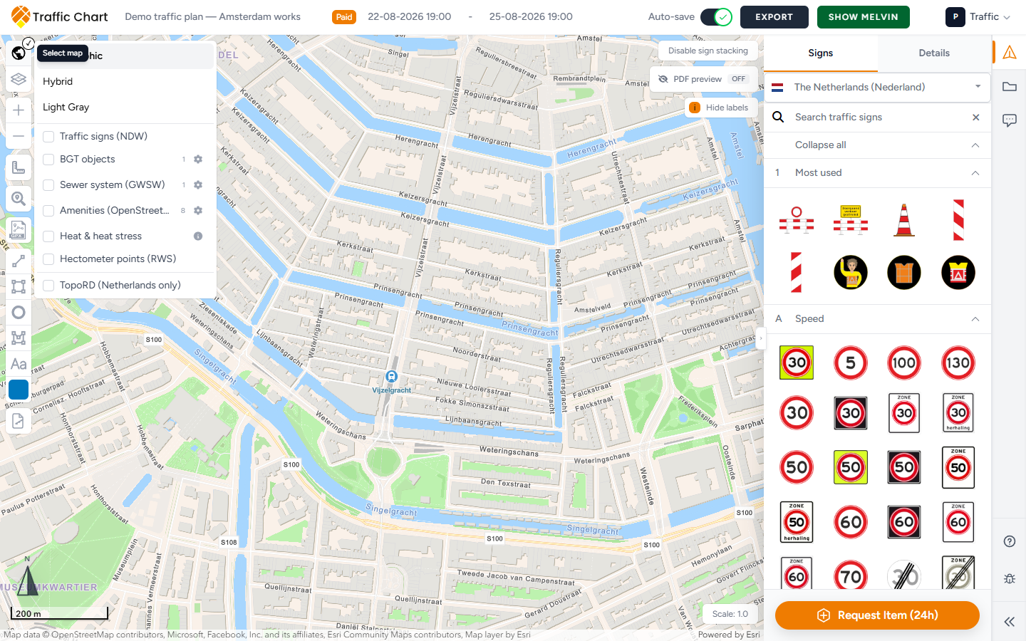
- Open Select map on the left (world-map icon).
- Pick a basemap. Common styles: Cartographic, Hybrid, Light Gray. If a style has no title, the fallback label is Map.
- For a Belgian plan, GRB (Flanders) also appears in this list. It is a Flanders reference basemap, not a Dutch overlay.
Basemap choice affects on-screen context and usually the look of exported map pages. Prefer a clear basemap before final export. Switching can take a moment; wait until the map finishes updating.
If the plan Country is not Belgium, GRB (Flanders) is hidden. If you had GRB selected and then switch the plan to the Netherlands, the map falls back to Cartographic.
Optional data checkboxes sit under the styles. They only show when the plan Country is the Netherlands.
Locked rows show This layer is locked. Clicking a locked object on the map can toast the same line.
Show Melvin
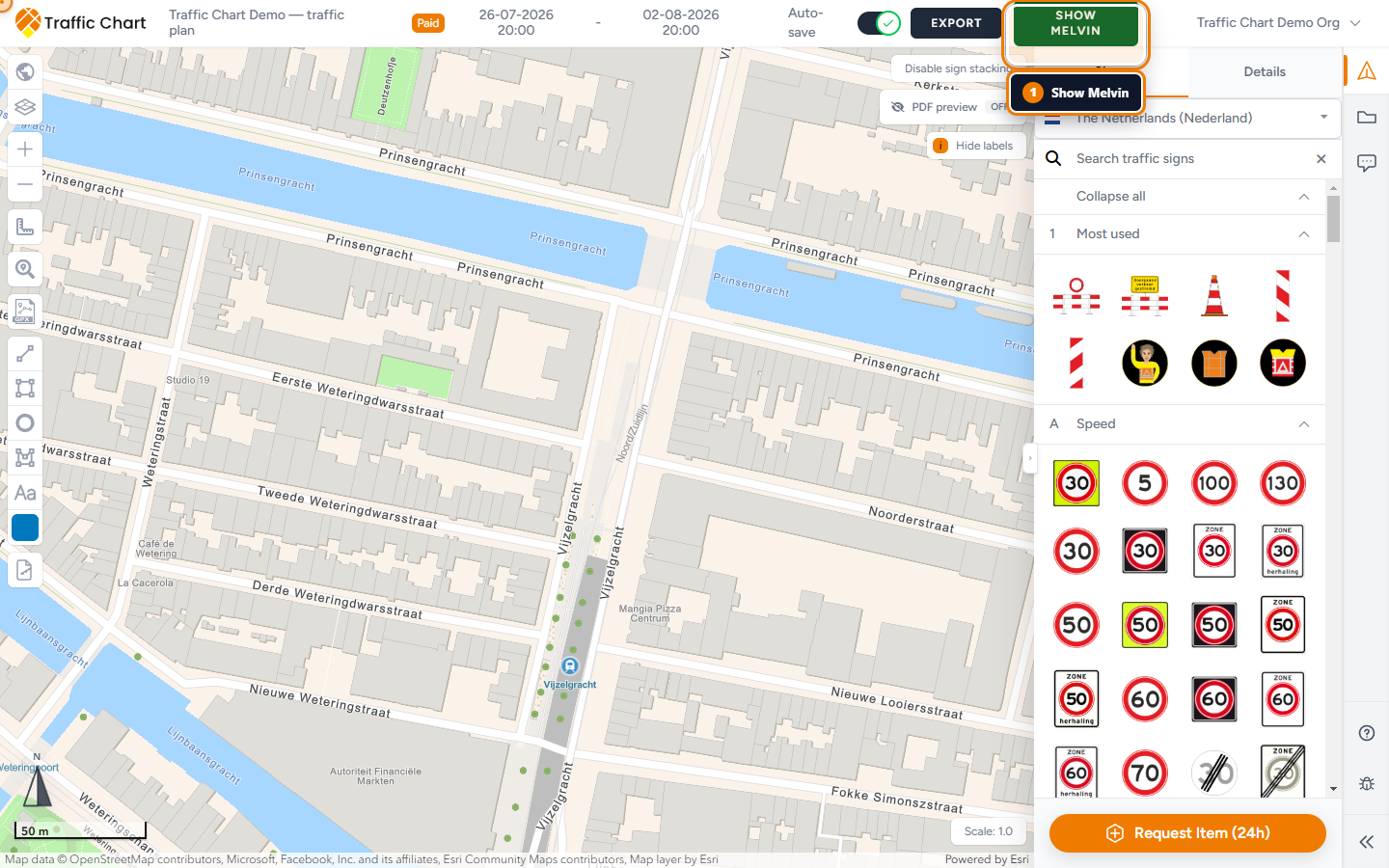
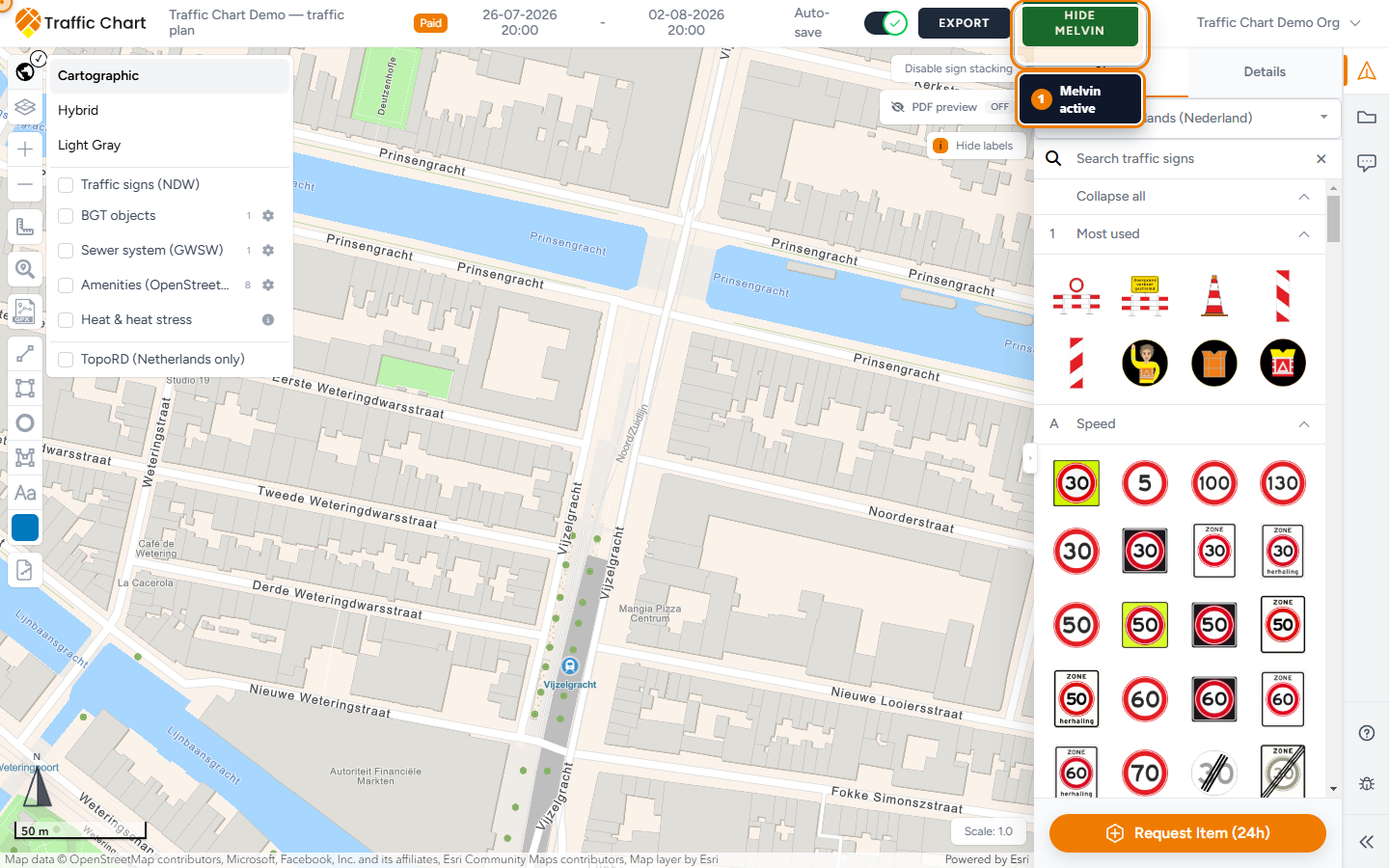
Show Melvin / Hide Melvin is in the editor header. It is a Netherlands roadworks overlay. The button only appears for Dutch plans.
Melvin needs complete dates. Until both are filled, the control stays disabled: Fill in a date to use this option.
- Set Start date and End date (date and time). Start must be before end.
- Pan to a location in the Netherlands.
- Click Show Melvin. It becomes Hide Melvin when the overlay is on.
- Treat what you see as context. Place and own your own signs. Melvin does not add plates to your catalogue or your materials list.
An empty overlay can be correct: no overlapping roadworks for that time and place. A Demo traffic plan dated next March on a quiet Utrecht side street may show nothing useful. That is not a broken plan.
If nothing useful appears after you toggle it, see Melvin or map layers not showing.
Traffic signs (NDW)
Netherlands-only checkbox in Select map: Traffic signs (NDW).
This is existing-sign data from the national database. It is not your catalogue. Zoom in if the layer looks empty. NDW signs do not count toward your free sign limit and do not appear on the materials list.
Use it to see what is already on street furniture before you add a temporary plate. Turn it off before export if the extra symbols crowd the PDF.
BGT objects
BGT objects is a set of large-scale Dutch topographic objects (hydrants, cabinets, poles, and similar). The count next to the name is how many object types you have selected. The checkbox can sit in a mixed (indeterminate) state when only some types are on.
Visible from about scale 1:50,000 and closer. Zoomed out, the hint is Zoom in further to show BGT objects.
Configure BGT objects
- Tick BGT objects.
- Open Configure BGT objects (gear).
- The panel title is BGT objects.
- Layer visible turns the whole layer Enabled or Disabled.
- Tick types under the three groups below. Select all / Clear all / Done.
- The back arrow closes the panel and returns to Select map.
Click a BGT symbol on the map for a popup: Type, Status, Source holder, Identification.
BGT does not specify whether a container is underground. That hint sits on Containers.
Emergency and safety
| Object | Use it when |
|---|---|
| Fire hydrants | You need hydrant positions for access or parking bans |
| Cameras | Camera poles or cabinets that affect a stack location |
Sewer and utilities
| Object | Use it when |
|---|---|
| Inspection and sewer manholes | Manhole lids in the carriageway or footway |
| Sewer cabinets | Roadside sewer kiosks |
| Drainage pits | Drainage collection points |
| Water-main pits | Water-main access |
| Gas pits | Gas-network pits |
| Electricity cabinets | Electrical distribution cabinets |
| Pumps | Utility pumps in public space |
Traffic and public space
| Object | Use it when |
|---|---|
| Containers | Street containers. Remember: underground vs above-ground is not in BGT |
| Height detectors | Height-detection devices |
| Traffic-signal poles | Traffic-signal poles (not your temporary plates) |
| Bollards | Removable or fixed bollards |
| Barrier gates | Barrier / boom gates |
| Bus-stop poles | Bus-stop poles |
| Road markings | Mapped road-marking objects |
Turn on only what the works need. A full selection on an Amsterdam inner-city export page is unreadable.
A practical Utrecht default is Fire hydrants, Electricity cabinets, and Bollards. Add Traffic-signal poles and Bus-stop poles at junctions. Leave Road markings off unless you are arguing about existing paint. Leave Cameras off unless privacy or sightlines matter.
The English labels above are exactly what Configure BGT objects shows. Translations also exist for Sirens and Emergency telephones, but those types are not in the current configure list — you cannot tick them.
Extra Dutch layers (supplemental)
Still in Select map, still Netherlands-only. Each row can show a small count of selected types. Configurable layers open a panel with the same Layer visible (Enabled / Disabled), Select all, Clear all, and Done as BGT.
Sewer system (GWSW)
Sewer system (GWSW) — inspection manholes, sewer pipes, pumps, and related objects. Short hint: Updated weekly; visible up to scale 1:10,000 and coverage varies by municipality. Attribution in the configure panel: Source: Stichting RIONED and Esri Nederland. Availability varies by municipality.
Zoom in past about 1:10,000. A municipality that has not published GWSW will look empty.
Tick any of:
| Object | What it is |
|---|---|
| Inspection manholes | Inspection pits |
| Sewer manholes | Sewer manholes |
| Overflows | Overflow pits |
| Discharge points | Discharge pits |
| Pumps | Sewer pumps |
| Sewer pipes | Pipes (drawn as lines) |
GWSW and BGT both have manholes and pumps. They are different datasets. You can run both; expect overlap. If you only need lids in the carriageway, Inspection and sewer manholes under BGT is usually enough. Use GWSW when the municipality asked for the sewer network, including Sewer pipes.
Amenities (OpenStreetMap)
Amenities (OpenStreetMap) — points contributed to OpenStreetMap. Short hint: Updated daily; completeness depends on OpenStreetMap contributions. Attribution: © OpenStreetMap contributors, powered by Esri Nederland.
Visible up to about scale 1:50,000. Completeness is volunteer data. An AED that exists on street may be missing here.
Tick any of:
| Object | What it is |
|---|---|
| AEDs | Defibrillators |
| Public toilets | Public toilets |
| Drinking-water points | Drinking-water taps |
| Parking | Parking areas |
| Bicycle parking | Bicycle parking |
| Bus stops | Bus stops |
| Charging stations | EV charging |
| Traffic signals | Traffic signals |
Heat & heat stress
Heat & heat stress is not a type list. It is one modelled overlay: Perceived temperature (heat stress).
It is not a live thermometer. Open About the heat-stress map:
This modelled map shows perceived temperature on an extremely hot summer afternoon, based on the spatial situation in 2022. It highlights where buildings, paved surfaces, limited wind and a lack of shade increase heat stress. This is not a current temperature measurement and local results are indicative.
Source line: Source: Climate Impact Atlas, Nelen & Schuurmans. Current as of April 2025; map version: 2022.
Use it as context for event comfort or shade, not as a weather forecast for Demo traffic plan’s Start date.
Turn Heat & heat stress off before a contractor PDF. The colour wash fights sign colours and does not belong on a permit drawing unless the municipality asked for heat context.
Hectometer points (RWS)
Hectometer points (RWS) — Rijkswaterstaat hectometre markers along national roads. Not configurable beyond on/off. Visible from about scale 1:24,000; labels (kilometre + side) appear when you zoom closer (about 1:10,000).
If the service fails when you tick it: The Rijkswaterstaat layer is temporarily unavailable. Attribution: Bron: Rijkswaterstaat, Nationaal Wegen Bestand (NWB).
TopoRD (Netherlands only)
Still under Select map, Netherlands-only: TopoRD (Netherlands only).
It is an extra topographic backdrop. Warning when the map centre is outside the Netherlands: Only available when the map center is in the Netherlands.
Pan the map into the Netherlands if you need it. It does not replace your sign catalogue.
GRB (Flanders)
GRB (Flanders) is a basemap for Belgian plans, listed with Cartographic and Hybrid. It is not a checkbox under the Dutch extras.
- Set plan Country to Belgium.
- Open Select map.
- Choose GRB (Flanders).
- Work in Flanders. Coverage is not the whole of Belgium.
If GRB (Flanders) is missing, the plan Country is not Belgium.
GRB can take a moment to appear in the list after you open Select map on a Belgian plan. Open the menu again if it is not there yet. If the service cannot load, stay on Cartographic or Hybrid and keep placing signs. Your plan is still valid without GRB.
Map information legend
When BGT or supplemental layers are on during PDF export, the file can add a Map information page. It lists the object types that were actually visible, with a colour dot per type, plus source lines for GWSW, OSM, heat, or hectometre data.
That page is a legend for the supporting layers. It is not your Materials list. Turn off unused types before Export now so both the map pages and Map information stay short.
On-screen you already have the configure panels and, for BGT, the popup fields Type, Status, Source holder, Identification.
The legend lists every selected and visible type from the catalogues below, not every type that exists in the Netherlands. If Fire hydrants is ticked but you never zoomed in, the hydrants may be missing on the map page and missing or incomplete on Map information. Zoom in on the export rectangle before Export now.
Layers & Objects
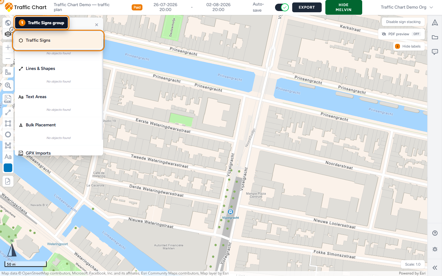
The second button in the layer stack is Layers & Objects. That list is your drawing, not NDW or BGT.
Typical groups: Traffic Signs, Lines & Shapes, Text Areas, Bulk Placement, GPX Imports.
Empty groups mean nothing is drawn there yet: No objects found.
| Action | Purpose |
|---|---|
| Lock layer / Unlock layer | Stop accidental edits on a whole group |
| Lock object / Unlock object | Protect one item |
| Zoom to object | Centre the map on that object |
Stacks can show a code plus (+2) when more plates sit on the same post, and an address line when one exists. Fallbacks: Sign, Shape, Text Area, Bulk line (12 signs) (the number is that line’s count), GPX Route.
Lock base sketches before you place many signs. This layer is locked if you try to edit a locked item.
Layers & Objects is also how you find a stack you buried under BGT symbols. Zoom to object, then turn BGT off if the hydrants are in the way. Your signs stay; the overlay is only context.
Zoom and scale cheat sheet
| Layer | Zoom / scale hint |
|---|---|
| BGT objects | Zoom in further to show BGT objects. (~1:50,000) |
| Sewer system (GWSW) | Visible up to ~1:10,000 |
| Amenities (OpenStreetMap) | Visible up to ~1:50,000 |
| Hectometer points (RWS) | Layer ~1:24,000; labels closer (~1:10,000) |
| Traffic signs (NDW) | Zoom in; empty is often too far out |
| TopoRD (Netherlands only) | Map centre must be in the Netherlands |
| Show Melvin | Needs Start date and End date |
| GRB (Flanders) | Belgian plan, Flanders location |
None of these replace your sign catalogue. Turn off what you do not need before export so pages stay readable.
What good looks like
The basemap is readable at street zoom. Show Melvin is on only while you need works context, then off. BGT objects is configured to Fire hydrants and Electricity cabinets (or the types you actually use), not all sixteen. GWSW or OSM is on only if the municipality asked. Layers & Objects can find every stack you care about. The PDF Map information page matches those ticks.
If something blocks you
| Symptom | Try this |
|---|---|
| Show Melvin greyed out | Fill Start date and End date. Tooltip: Fill in a date to use this option |
| NDW, BGT, GWSW, OSM, heat, hectometer, or TopoRD missing | Plan Country is not the Netherlands |
| GRB (Flanders) missing | Plan Country is not Belgium |
| Layer empty | Zoom in; check the map centre |
| Zoom in further to show BGT objects. | Zoom in |
| The Rijkswaterstaat layer is temporarily unavailable. | Retry later; keep drawing |
| TopoRD (Netherlands only) warning | Move the map centre into the Netherlands |
| This layer is locked | Unlock layer / Unlock object in Layers & Objects |
| Fire hydrants empty (legacy hint) | Zoom in. Older copy: Zoom in further to display fire hydrants. |
Full checklist: Melvin or map layers not showing.