This page is the drawing lesson for an event plan: catalogue objects, zones, routes, and map labels. Create the plan first. Then stay here while you fill the site.
When you need this
Use it when the editor is already open and you need to place something on the map.
Skip it if you only need to create the plan, export a PDF, or wait on municipal review. Those are Event plans handbook, Export an event plan, and Review for organisers.
Wait until the map is ready. If you click too soon, Objects can toast Map is not ready yet.
There is no Texts module in the right-hand strip. Labels go on the map with Add text. Comments is municipal review, not a drawing tab.
Where drawing lives
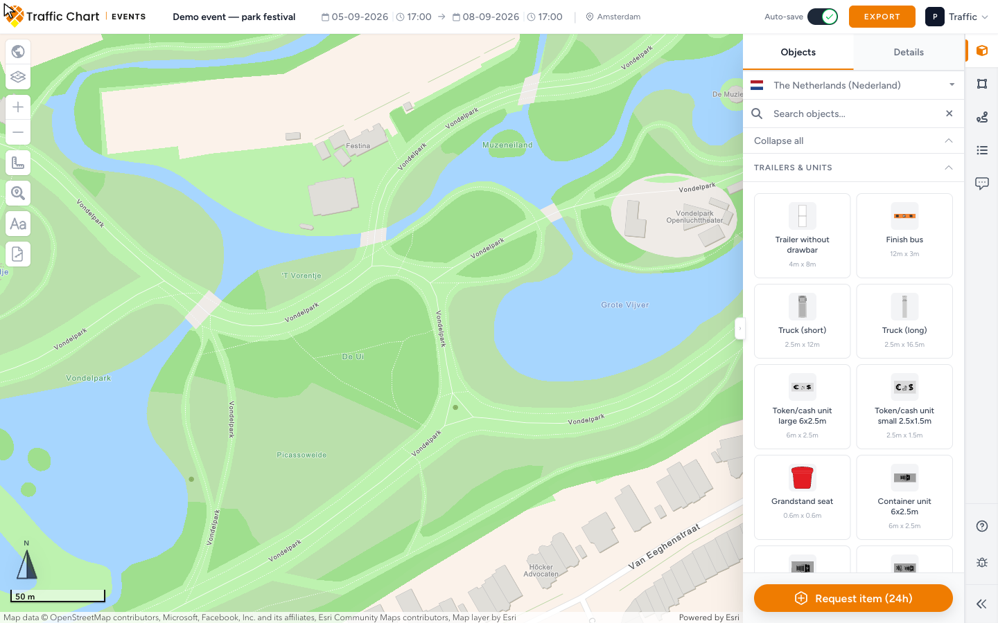
The right-hand strip has four modules: Objects, Areas, Lines & Routes, and Comments.
Each drawing module has two tabs at the top of the panel: the catalogue tab, then Details. Select something on the map, then open Details. If nothing is selected, Details says Select an object, area, line or text to view its details.
Export is a header button, not a module. Save and Auto-save sit in the header. Wait until Auto-save: saved (or a finished Save) before you close the tab.
Add text is the Aa control on the left of the map. It is a map tool. It is not a sidebar tab.
Layers on the left of the map lists what you already placed: Event Objects, Event Areas, Lines & Routes, and Texts. From a row you can Zoom to, Lock item / Unlock item, and Show labels / Hide labels for that layer. Lock entire layer / Unlock entire layer locks every item in that group. An empty group says No items in this layer.
If the plan is locked, Objects, Areas, and Lines & Routes stay disabled. The tooltip is This event plan is locked and cannot be edited. You can still open Comments.
Objects
Open Objects. This is the furniture and kit catalogue: tents, toilets, generators, fencing, and the rest of the site kit.
Search and categories
The search field is Search objects.... It matches object names and codes. If nothing matches, you see No objects found.
Collapse all / Expand all folds or opens every visible category.
English category names:
| Category | Typical use |
|---|---|
| Furniture | Tables, benches, and similar site kit |
| Safety & Security | Barriers, first aid, security posts |
| Food & Drinks | Bars, food stalls, water points |
| Fencing | Fence runs and gates |
| Trailers & Units | Cabins, trucks, production units |
| Flags & Banners | Flags, banners, and wayfinding boards |
| Power Supply | Generators, distribution, cabling points |
| Sanitary Facilities | Toilets, showers, wash units |
| Waste | Bins, skips, recycling |
| Water & Cleaning | Water tanks and cleaning points |
| Entertainment | Stages, screens, attractions |
| Staff | Crew and steward positions |
| Mobility | Bikes, buggies, accessible kit |
| Other | Types that do not sit in a named category |
Each tile shows the type name. If the catalogue has a default size, the tile also shows it as metres by metres, for example 2m x 3m.
Place an object
- Click a type. The tile highlights and the cursor becomes a crosshair. Click the same type again to cancel.
- Click the map once. The object drops at that point.
- Select it. The on-map toolbar is Move, Rotate, Duplicate, Edit, Deselect, and Delete. Corner handles are Resize from top left, Resize from top right, Resize from bottom right, and Resize from bottom left.
- Edit opens Details.
If the object layer is not ready, the app toasts Map is not ready yet. Wait, then try again.
Need a type that is not in the list? Use Request item (24h) at the bottom of Objects. That opens a request form. Describe the item. Keep drawing with the closest type if the event cannot wait.
Placed event objects are what in-app review uses to attach the plan to a municipality. Areas, lines, and text do not count. If Comments later says Place event objects to start a review, put at least one object on the real site. See Review for organisers.
Object Details
| Control | What it does |
|---|---|
| Type | Catalogue name. Read-only. |
| Attention points | Extra notes for that type, each tagged Info, Warning, or Important. |
| Label | Crew tag. Placeholder Optional label... |
| Tag button | Enable label on map / Disable label on map. Same idea as Show label on map. |
| Image-fit button | Keep image aspect ratio (Contain) or Stretch image to object (Stretch). See below. |
| Ruler button | Enable measurements / Disable measurements. |
| Colour swatch | Choose contain background color when aspect ratio is on. |
| Width (m) | Width on the ground. Disabled when the type is not scalable. |
| Length (m) | Length on the ground. Disabled when the type is not scalable. |
| Rotation | Degrees, 0–360. |
| Delete Object | Removes it from the map. |
Image fit: Contain or Stretch
Image fit only matters for types that have a picture.
- Contain keeps the picture’s aspect ratio inside the object rectangle. Extra space uses Contain background.
- Stretch fills the rectangle and can distort the picture.
Turn Contain on first if you want a background colour. If you click the colour swatch while the object is in Stretch, a toast says Background colors work with aspect ratio mode. Turn on aspect ratio mode to choose a color. The image-fit button pulses so you can find it.
With Contain on, the colour menu includes Choose contain background color. For pictured types it also includes Use transparent background. Transparent fill forces Stretch. The toast is Transparent background uses stretch mode, so image aspect ratio was turned off.
Areas
Open Areas. Draw the site zones: camping, crowd, parking, tents, restricted ground, and generic patches.
Shape
Pick a Shape before you pick a type:
| Shape | How you draw |
|---|---|
| Polygon | Click each corner. Finish the shape to close it. |
| Rectangle | Click and drag a box. |
| Circle | Click and drag a radius. |
Stay in Areas so Shape and Area Type stay together. Click the same Area Type again if you started the wrong one.
Area Types
Click a type to start drawing. Click the same type again to cancel.
| Type | Description in the app |
|---|---|
| Camping | Camping / overnight area |
| Crowd Area | Public gathering zone |
| Parking | Vehicle parking area |
| Tent / Pavilion | Covered structure area |
| Restricted Zone | No-access / staff only area |
| Generic Area | General purpose zone |
Give public space and Restricted Zone a colour difference the crew can see at a glance.
Area Details
| Control | What it does |
|---|---|
| Area Type | The type you picked. Read-only. |
| Name | Placeholder Area name... |
| Show label on map | Prints the name on the zone. |
| Show surface area | Area in square metres. |
| Show overall size (L × W) | Bounding length and width. |
| Show side lengths | Length of each edge. |
| Show corner angles | Angle at each vertex. |
| Color | Fill colour. |
| Opacity | Slider from 10% to 100%. |
| Width (m) / Length (m) | Ground size when the shape supports it. |
| Delete Area | Removes the zone. |
Toggle tooltips match the action: Enable label on map, Enable measurements, Enable overall size, Enable side lengths, Enable corner angles, and the matching Disable … labels when the option is already on.
Lines and routes
Open Lines & Routes. Draw visitor paths, vehicle paths, emergency paths, and the site boundary.
Line Types
Click a type, then click along the map. Click the same type again to cancel.
| Type | Description in the app |
|---|---|
| Boundary | Boundary line of the event area |
| Pedestrian Route | Walking route for visitors |
| Vehicle Route | Route for vehicles |
| Emergency Route | Emergency access route |
| Access Route | Access route for visitors |
| Emergency Exit | Emergency exit route |
Barrier is not in this picker. Older plans can still have a Barrier line. If you select one, Details still shows Line Type Barrier. Draw new fence as Fencing objects, or as a Boundary line, not as a hidden barrier type.
Keep Emergency Route and Emergency Exit visually distinct from visitor Pedestrian Route and Access Route.
Placed lines
The Lines & Routes panel is the picker. After you draw, the line stays on the map. That is your placed line.
To find it again:
- Open Layers.
- Expand Lines & Routes.
- Click the row. The app selects the line and opens Details.
Or click the line on the map, then open Details.
Line Details
| Control | What it does |
|---|---|
| Line Type | The type you picked. Read-only. |
| Name | Placeholder Line name... |
| Tag button | Enable label on map / Disable label on map. |
| Ruler button | Enable measurements / Disable measurements. |
| Color | Stroke colour. |
| Style | Solid, Dashed, or Dotted. |
| Direction | Back, None, or Fwd. Fwd and Back draw arrows along the path. None is a plain stroke. |
| Delete Line | Removes the path. |
Add text
Add text lives on the left of the map, with the zoom and layer tools. The control is the Aa button. Title: Add text.
It is not a sidebar module. Do not look for Texts next to Objects.
- Click Add text. The cursor becomes a crosshair.
- A toast says Click once on the map to place text. The text options stay available in the sidebar while you type.
- Click once where the label should sit, then type.
- Select the text. The on-map toolbar is Edit, Deselect, and Delete. Corner handles resize it (Resize from top left, and the other corners).
Layers lists these labels under Texts. A row with no words falls back to Text. Meta can show Size: and the point size.
Text Details
| Control | What it does |
|---|---|
| Text | The words on the map. |
| Font Size | Slider and number field. |
| Color | Letter colour. |
| Rotation | Degrees. |
| Alignment | Click to cycle Left, Center, Right. |
| Weight | Regular or Bold. |
| Background | None, Halo, or Box. |
| Background color | Fill behind Halo or Box. |
| Delete Text | Removes the label. |
Short labels survive export better than paragraphs. Put crew notes on objects with Label, and put wayfinding on Add text.
What good looks like
- Every important piece of kit is an Objects type on the real pitch, not only a coloured zone.
- Camping, Crowd Area, Parking, Tent / Pavilion, and Restricted Zone do not share one muddy colour.
- Emergency Route / Emergency Exit stay readable next to visitor routes.
- Show label on map is on for anything crew must read without opening Details.
- Contain is on for pictured objects that must keep their shape; Stretch is on only when you want the picture to fill the box.
- At least one event object sits on the site if a municipality will review in the app.
- Save or Auto-save: saved has finished.
If something blocks you
| Situation | What to try |
|---|---|
| Map is not ready yet | Wait until the map finishes loading, then place again. |
| No objects found. | Clear Search objects..., or use Request item (24h). |
| No Texts tab | Expected. Use Add text on the map. |
| This event plan is locked and cannot be edited. | Review lock. See Review for organisers and I can’t open or edit a plan. |
| Event plans says Not enabled for Personal. | Event plans handbook |
| Need a PDF | Export an event plan |