
This page turns on Melvin and other optional map layers, or explains why they stay empty.
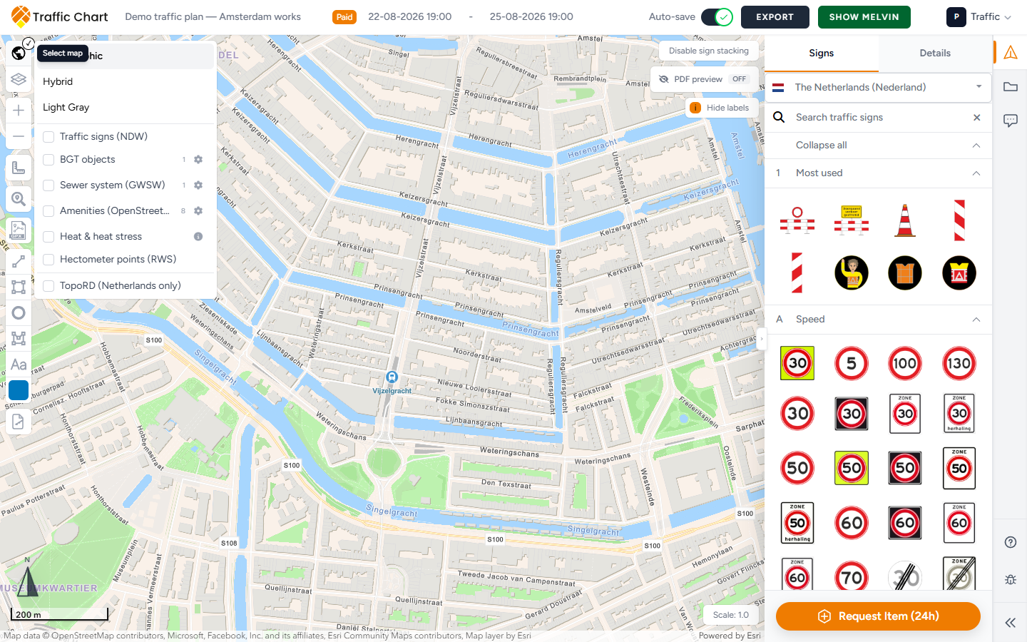
Use it when a toggle is grey, the overlay is blank, or a basemap looks wrong. Missing layer data does not block you from drawing signs. Your placed objects remain the plan of record.
If the whole map is white, fix that first: Map will not load or stays blank. This page assumes Opening Map Environment... is already gone.
Melvin (Netherlands)
Melvin is optional Dutch roadworks context. It needs both plan dates.
- Set complete Start date and End date (date and time). Until then, Show Melvin stays disabled: Fill in a date to use this option.
- Pan to a location in the Netherlands.
- Click Show Melvin in the header (it becomes Hide Melvin when on).
- Wait for the overlay, then pan to the works area.
An empty Melvin overlay can be correct: no overlapping roadworks for that time and place.
The button only appears for Dutch plans. A Belgian Country will not show Show Melvin.
Other layers
Open Select map on the map tools. Availability depends on location, zoom, and configuration. Locked layers show a tooltip, often This layer is locked. Clicking a locked object can toast the same line.
| Symptom | Try this |
|---|---|
| Layer empty | Zoom in. Many layers have a minimum scale. |
| Fire hydrants (BGT) empty | Zoom in further. Tooltip: Zoom in further to display fire hydrants. |
| BGT objects empty | Zoom in. The panel says Zoom in further to show BGT objects. Use Configure BGT objects if you need specific classes. Select all / Clear all / Done. Toggles: Layer visible, Enabled / Disabled. |
| TopoRD (Netherlands only) missing | The map centre must be in the Netherlands. Tooltip: Only available when the map center is in the Netherlands. |
| GRB (Flanders) empty | Use it on a Belgian / Flanders location. Coverage is not nationwide. If the control is missing, the plan Country is probably not Belgium. |
| Traffic signs (NDW) empty | Zoom closer. NDW is existing-sign context, not your catalogue. |
| Hectometer points (RWS) missing | The Rijkswaterstaat layer is temporarily unavailable. Try later. |
| Sewer system (GWSW) empty | Zoom to about 1:10,000. Coverage varies by municipality. |
| Heat & heat stress unclear | Read About the heat-stress map. It is a modelled summer afternoon, not a live thermometer. |
| Basemap wrong | In Select map, pick Cartographic, Hybrid, Light Gray, or the fallback Map. |
BGT does not specify whether a container is underground. Treat hydrants and cabinets as context. Your placed signs remain the plan of record.
Traffic signs (NDW) are existing roadside plates in the Dutch register. They are not your catalogue and they do not go on the Materials list. Place your own signs from Traffic Objects → Signs.
Supplemental layers vary by municipality. Empty is often coverage, not a defect.
Event plans use a shorter Select map: NDW Signs, Fire hydrants (BGT), TopoRD (Netherlands only). Same zoom rules. Event hydrant tooltip: Zoom in further to display fire hydrants. Those layers do not place event objects. Event map layers and hydrants.
What good looks like
Show Melvin is clickable after both dates are set. The overlay appears where Melvin has data. Other checkboxes in Select map behave as the tooltips describe. Map information can still list visible layer types on a PDF legend page.
Next click
| You see | Do this |
|---|---|
| Fill in a date to use this option | Set Start date and End date, including the time. |
| Zoom in further to show BGT objects. | Zoom in, then reopen Configure BGT objects. |
| Zoom in further to display fire hydrants. | Zoom in over Utrecht (or the works). |
| Only available when the map center is in the Netherlands. | Search address to a Dutch place, then tick TopoRD (Netherlands only). |
| The Rijkswaterstaat layer is temporarily unavailable. | Leave Hectometer points (RWS) off and draw without it. |
| This layer is locked | Unlock layer in Layers & Objects, or leave it locked if you meant to freeze it. |
| GRB (Flanders) missing | Check plan Country is Belgium. |
If it still fails
You can keep drawing. Full layer guide: Map layers and Melvin. Editor chrome: Tour of the traffic plan editor.